|
Reported Crop Circles for the State
of Indiana -
Washington Center / Washington Township, Noble County (July 20, 1996)
This over 200' long formation went nearly unobserved and unreported. The formation, discovered by the farmer (name withheld), was harvested right away. He took no pictures of it, but the formation, over a month later, came to the attention of researchers surveying nearby formations at Indian Village (about 1-2 miles away) and Columbia City (about 10 miles away).
The diagram (at left) is the best reconstruction of the formation. The formation consisted of an 101' diameter ring swirled counter-clockwise; a second section had a ring of standing wheat, with a small swirled circle at its center; a third part was a NE pathway connected to a 45' diameter ring swirled counter-clockwise with standing wheat at its center. The NE pathway continued to a 33' diameter circle swirled counter-clockwise.
This formation was set back from the nearest road by approximately 1/2 mile and was located in a very rural area with no communities nearby for miles.
 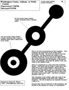
Crop
type: wheat
Source: personal investigation, Roger Sugden
Photo: Roger Sugden; Diagram: Jeffrey Wilson
|
|
City
/ County / Date:
- Dale,
Spencer County
(June 14, 1964)
- Cannelton,
Perry County
(June 17, 1964)
- Middlebury,
Elkhart County
(June 22, 1966)
- [Unknown]
(1972)
- Greenfield, Hancock County (November 8, 1978)
- Copley
Woods (?), (July 31, 1983)
- Middletown, Henry County
(May 27, 1987)
- Anderson / Middletown, Allen County (May 31, 1989)
- Warsaw, Kosciusko County
(June 27, 1990)
- Noblesville,
Hamilton County (June 7, 1994)
- Troy,
Spencer County
(June, 1994)
- Greensburg
/ Napoleon, Decatur County (September 11,
1994)
- Indian Village, Noble County
(July 1,
1996)
- Etna Troy Township / Columbia City, Whitley County
(July 14, 1996)
- Washington Center / Washington Township, Noble County
(July 20, 1996)
- Kewanna,
Fulton County
(August 7, 1996)
- New
Lake, Etna Troy Township, Whitley County (December 1996)
- Whitley County (July, 1996)
- Huntingburg, Dubois County (March 11, 1998)
- Spencer
/ Owen Valley, Owen County
(July 17, 2000)
- Bedford,
Lawrence County (December 12, 2004)
- Noble County (January 31, 2005)
- Albion,
Noble County
(April, 2005)
- Huntingburg, Dubois County
(June 26, 2006)
- Bedford, Lawrence County (September 13, 2008)
|


